Reimagining an aging office site for the next generation of Weston.
Project Summary
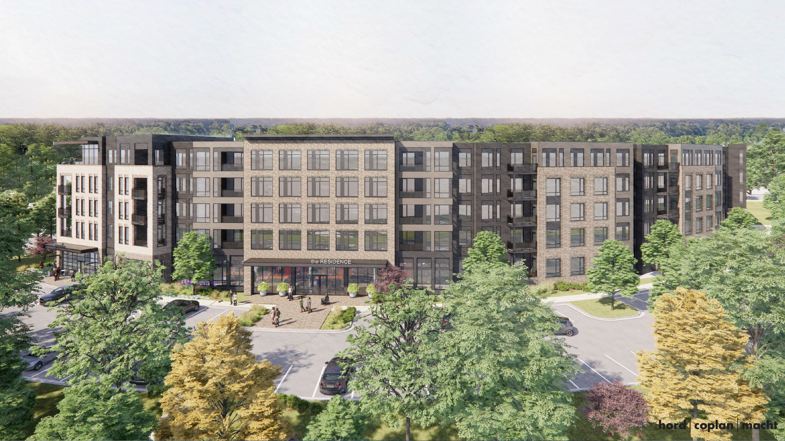
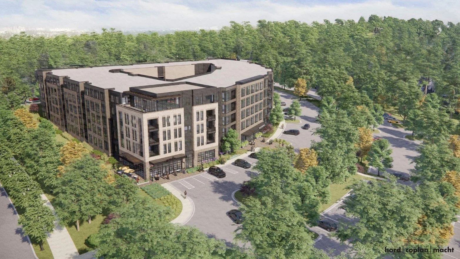
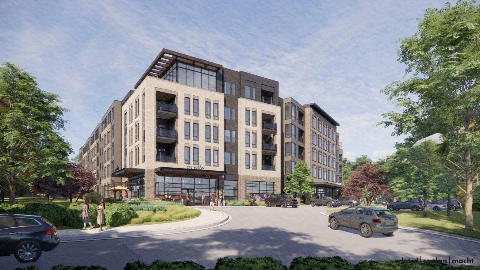
The proposed redevelopment project at 7001 Weston Parkway calls for a five-story multifamily building sited at the corner of Weston Parkway and Norwell Boulevard, nearly the exact footprint of the existing office building, and the section of the site farthest from existing single-family homes.
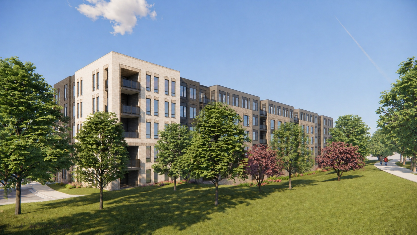
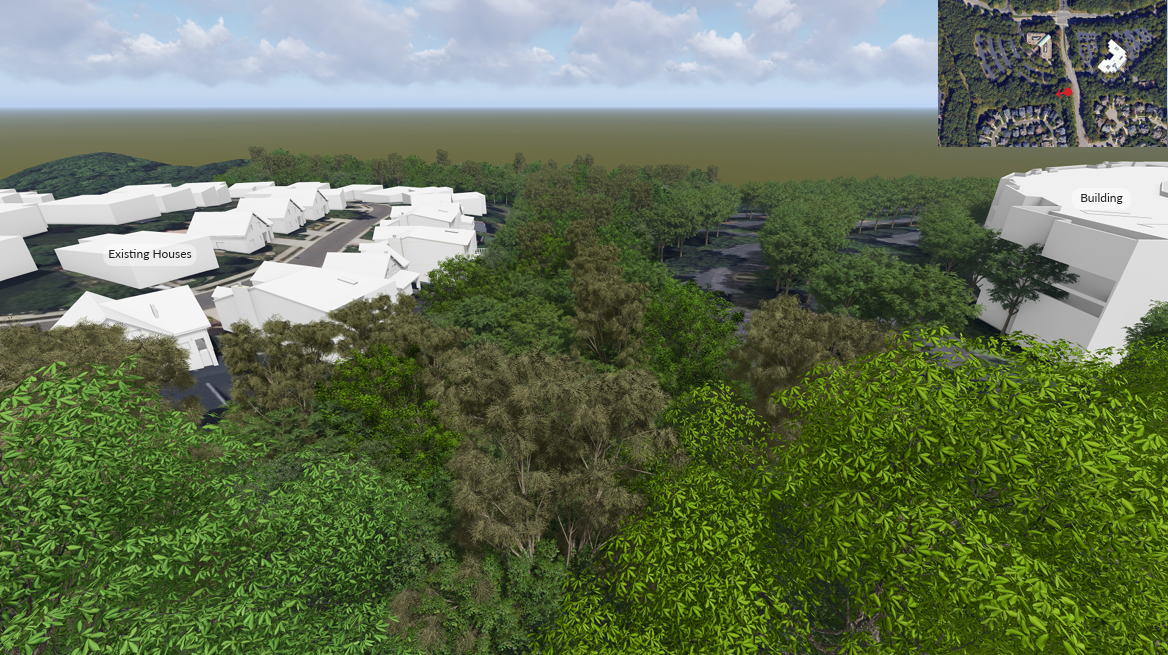
The plan intentionally preserves the remainder of the property, allowing the existing surface parking and mature tree canopy along the southern and western edges to be preserved, as much as possible, continuing to function as a natural buffer between the new building and the surrounding neighborhoods. The site plan and renderings below show the proposed project as currently designed.
Rezoning Request
The office building at 7001 Weston Parkway has become obsolete in today’s office market. The question before Council is not whether this site will be redeveloped—it can be—but what form that redevelopment takes, and whether the outcome serves the surrounding neighborhood and the broader Weston district.
This site is being redeveloped in collaboration between Highwoods Properties and Kane Realty Corporation. Together, the applicant has worked closely with planning staff and the adjacent community to arrive at a plan that reflects both the evolving nature of the Weston office market and the needs of the residential neighborhood at its edge.
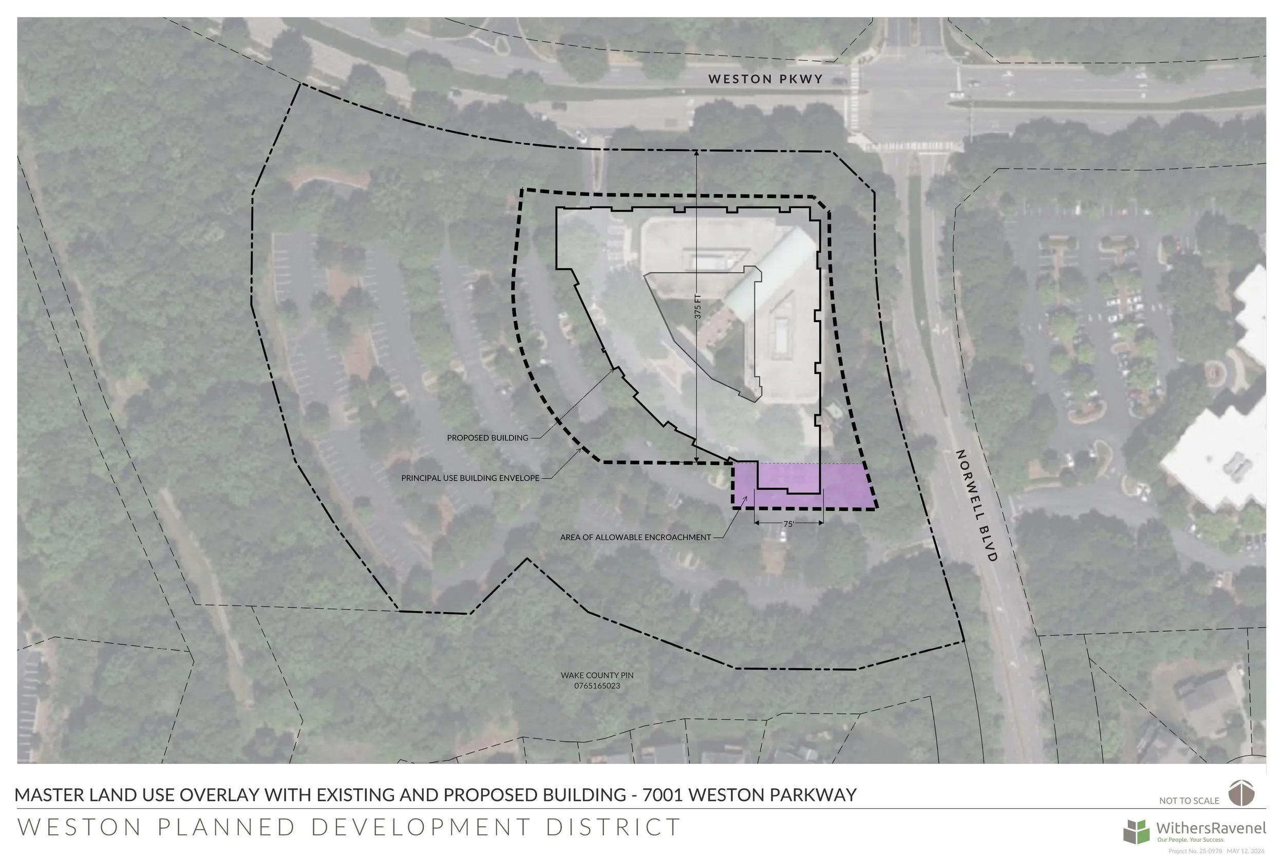
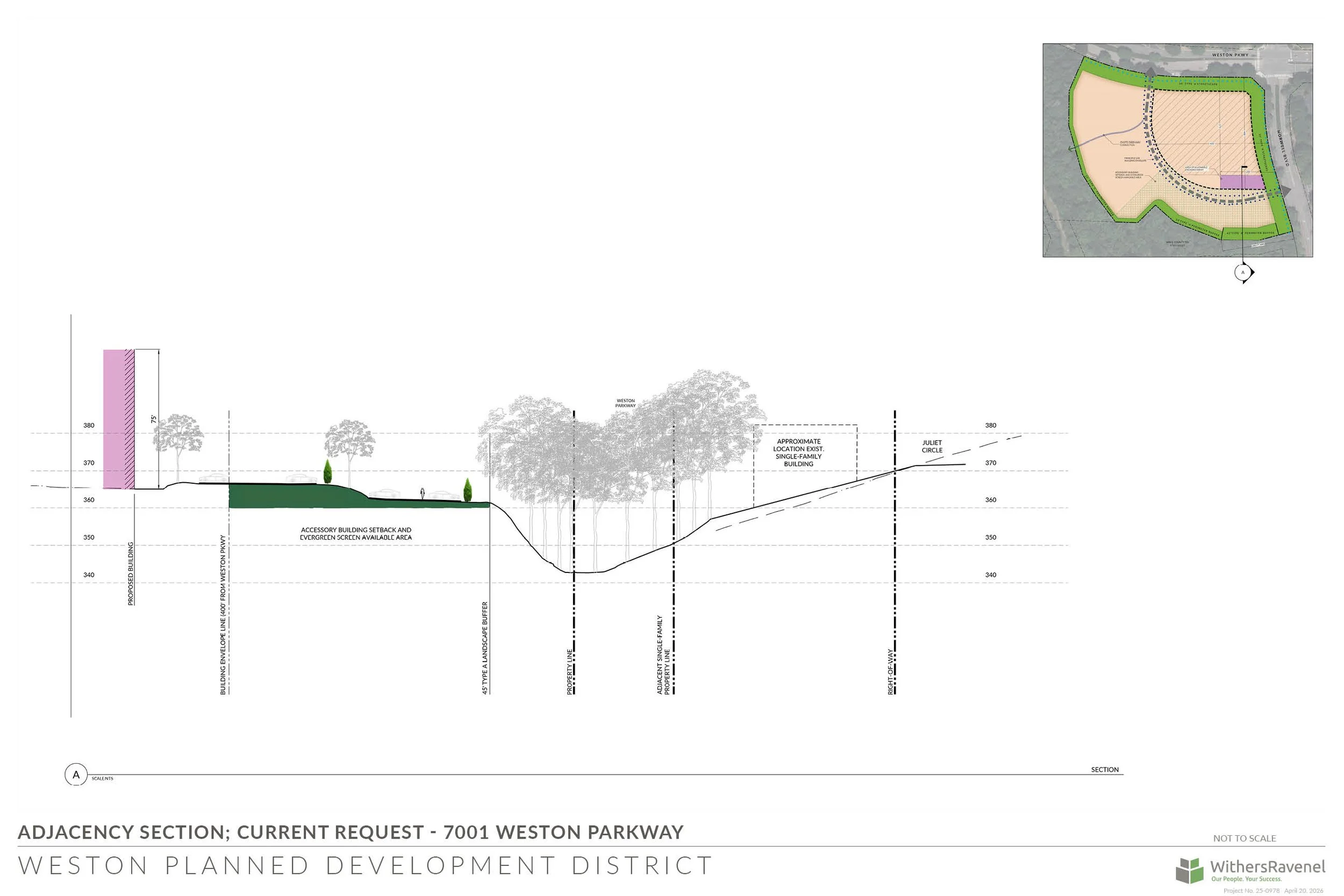
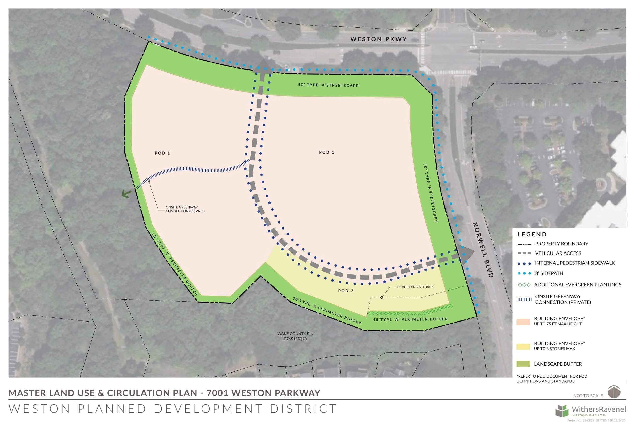
Overlay of Proposed Building, Principal Use Building Envelope, and Existing Building
Aerial View from Weston Parkway
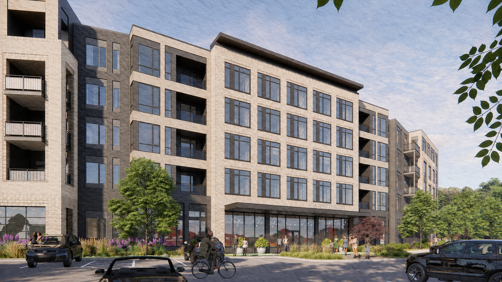
View from Weston Parkway
View from Surface Parking
View from Nowell Boulevard
What is being requested?
A refined plan, shaped by neighborhood input.
The current request reflects a significant evolution from the applicant's original proposal and responds to market signals about the future of the Weston district.
Weston has long been one of the Triangle's premier office addresses. But the broader office market is changing: tenants increasingly favor mixed-use environments where employees can walk to housing, retail, and amenities. Converting an aging single-use office site at the edge of an established neighborhood into a mixed-use residential community is consistent with where Weston is headed, and with how similar districts across the region are evolving.
The plan before Council confines a five-story multifamily building to a single corner of the site—the corner of Weston Parkway and Norwell Boulevard, where the existing office building sits today, and the point furthest from existing single-family homes. The remainder of the site offers the ability to preserve the existing surface parking and mature tree canopy, which continue to serve as a natural buffer between the new building and surrounding neighborhoods.
Following feedback from the initial public hearing, neighborhood meetings, and Planning & Zoning Board, the plan was resubmitted to the Town in April. Key elements of the current plan include pushing the building further north toward Weston Blvd. and a limitation on accessory structures between the building envelope and southern property line, creating a building setback that averages 180’ from the southern property line; a 45-foot-wide Type A perimeter landscape buffer, including upper-story and evergreen understory trees to provide the greatest degree of screening between usues; and a dense evergreen screen that further separates the building from adjacent residential properties. The existing surface parking and mature trees along the southern and western edges of the site are preserved as much as possible. A greenway connection along Weston Parkway, internal pedestrian sidewalks, and ground-floor retail space activate the Weston Parkway frontage. The building will include up to 275 apartments, providing a range of housing options within walking distance of employment and services. Ground-floor retail of between 1,500 and 5,000 square feet will serve both new residents and the existing office community nearby.
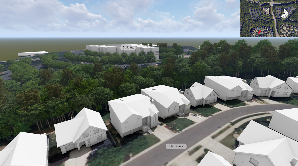
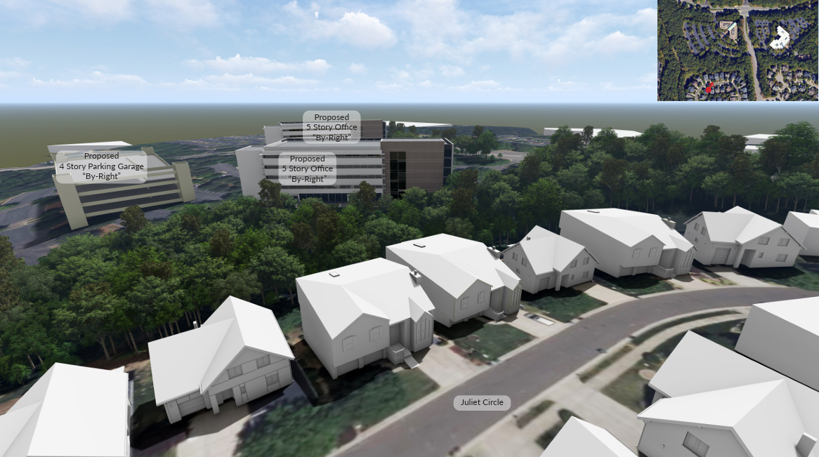
From the vantage point of Juliet Circle, the difference between the by-right scenario and the proposed plan is visible and significant. The renderings show the proposed building situated well behind the existing tree canopy, with the neighborhood streetscape essentially unchanged at grade.

May 2026 PDD Master Plan
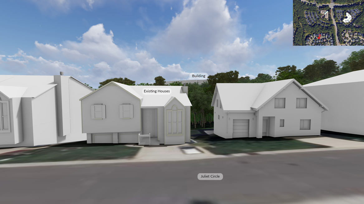
Street level view of proposed development from Juliet Circle
Aerial view of proposed development from Juliet Circle
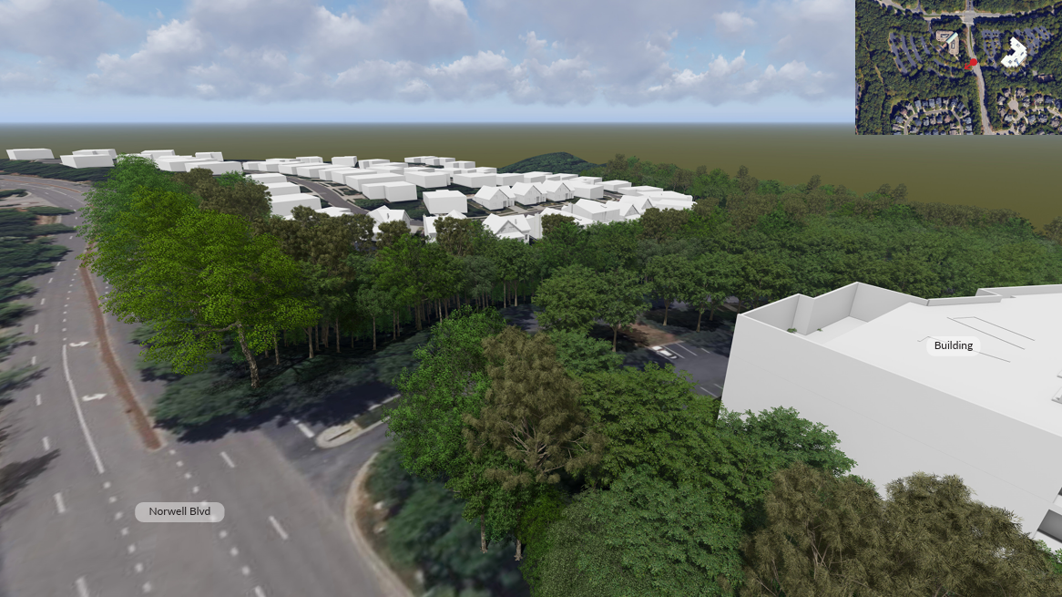
Aerial view of proposed development & neighborhood from Norwell Blvd
Aerial view of proposed development & neighborhood from Norwell Blvd
How did we get here?
September 2025 PDD Master Plan
A process shaped by community feedback.
The current plan is the product of community engagement, collaboration with town staff, and advancement of the building design. The applicant's original rezoning request proposed converting the site to a mix of residential uses: 45-foot-tall townhomes along the edges nearest to existing homes, with a taller multifamily building occupying the remainder of the site.
This represented a meaningful step away from what could be built on the site without any approval: residential uses are more compatible with the surrounding neighborhood than large commercial office buildings, and the townhome buffer was intended to provide a transition in scale. After further conversation with planning staff and neighbors, the applicant returned to the drawing board to address remaining concerns about the placement and massing of the taller building relative to the surrounding neighborhoods. The result is the plan before the Town Council today.
Changes since the original application include:
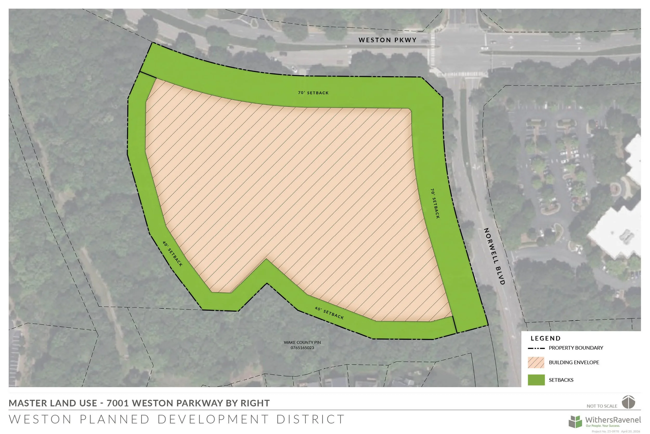
Building Location: The new multifamily building(s) must be built within a defined "building envelope" in the northeast corner of the site—roughly where the existing building sits today. Nothing can be built outside this zone in the southern portion of the site, a setback that averages 180 feet from the southern property line. This is a significant change from the September 2025 version of the plan reviewed at the Public Hearing, which would have allowed buildings 15 to 75 feet from the property line.
And, if the applicant is able to obtain relief from connectivity rules at development plan, the building will be pulled north to within 375’ of Weston Parkway, except for the purple range shown on the PDD master plan, approximately 200 feet from the southern property line.
All of this is in addition to the generous HOA buffer between the Juliet Circle homes and the Weston southern property line, which ranges from approximately 45 feet to 200 feet.
Building Setback: There will be no structures between the southern property line and the building envelope. This is an increase from a 75' accessory building setback included in previous versions of the application, keeping any accessory structures well away from neighbors. Any accessory structures are limited to the western portion of the site and cannot exceed 1 story until they reach the building envelope.
Height: Any accessory structures outside the building envelope are limited to 1 story. Previously, most of the site could have been up to 5 stories tall.
Density: Total units reduced from 297’ to 275’.
Evergreen Screen: Instead of a 6-foot fence along the southern property line, the plan now includes a denser planting of evergreen plants–25 per 100 linear feet (up from 14), each planted at a minimum of 2 feet tall and growing to at least 10 feet at maturity. The planting plan was developed with the Town's arborist to ensure the plants will thrive and provide effective long-term screening.
Commercial Space: The non-residential space (1,500–5,000 sq ft) must be a separate tenant-facing business, such as a coffee shop or restaurant—it cannot simply serve as an amenity for residents.
Sidepaths: Minimum sidewalk/path width on Weston and Norwell increased from 8’ to 12’.
Affordable Housing: The affordability restriction period for qualifying units has been extended from 20 years to 30 years.
What could be built ‘by-right’ without a rezoning?
No public hearing required.
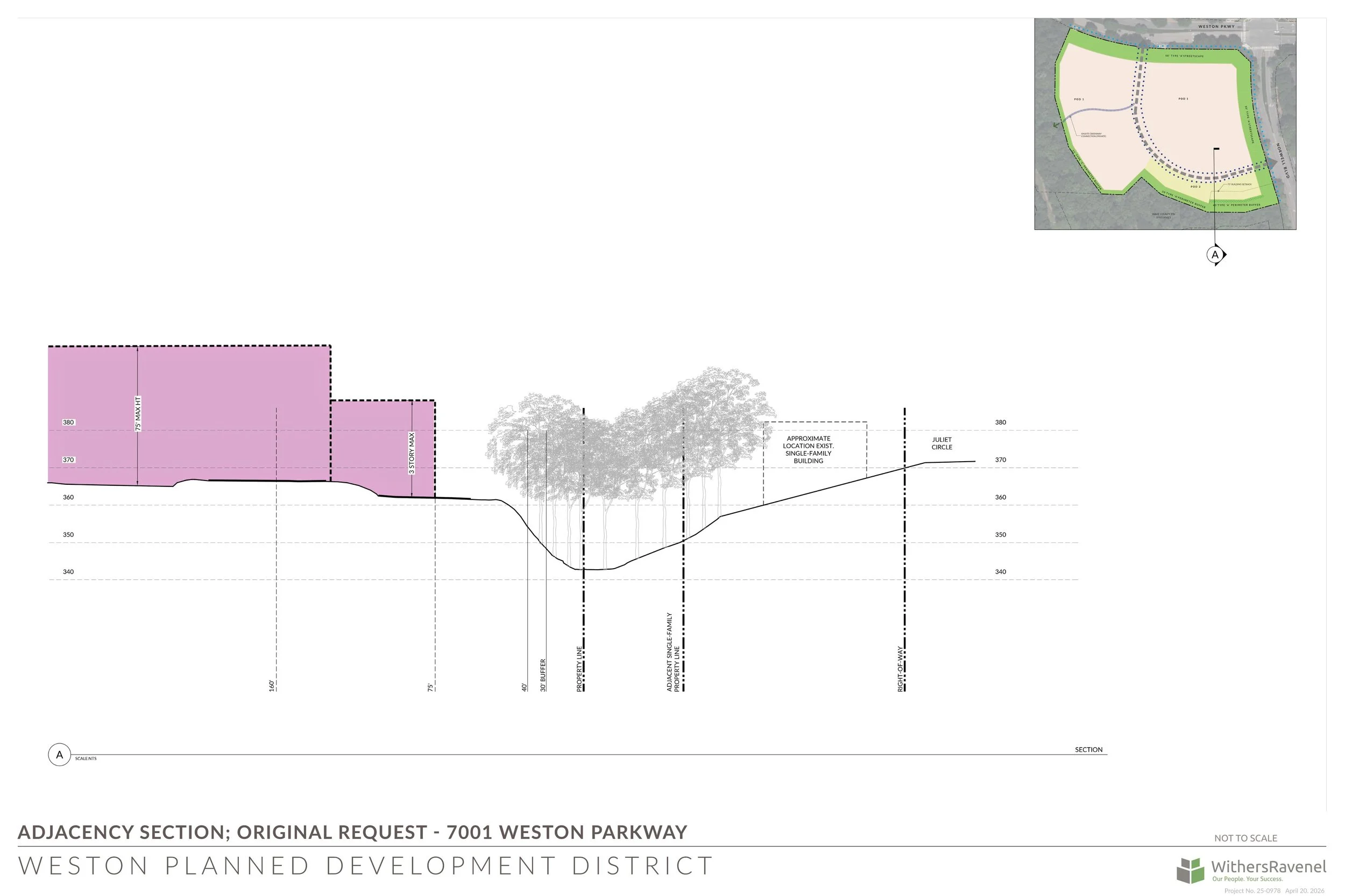
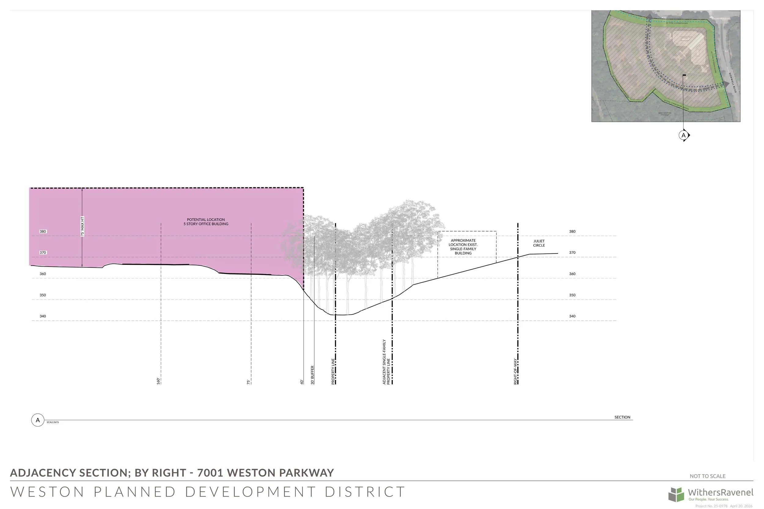
To understand why the rezoning matters, it helps to understand the alternative. Under the site's current office zoning, the applicant could move forward with 75-foot-tall commercial buildings across the entire site; those 75-foot buildings could be located as close as 40 feet from the southern property line and 70 feet from the eastern property line, as shown below—no public hearing, no community input, no Council vote required.
The trajectory of the broader Weston office market makes this scenario more likely, not less. To remain competitive, office properties in submarkets like Weston are densifying—adding building area, structured parking, and campus amenities to attract and retain tenants. The neighboring Centregreen Office Park, also developed by Highwoods Properties, is a direct example: that campus has added 5-story office buildings, a structured parking deck, a fitness pavilion, and a café as part of a deliberate effort to create the kind of amenitized environment today's tenants expect. Applied to 7001 Weston, that same logic points toward exactly what the by-right renderings show—taller buildings pushed closer to surrounding neighborhoods, surface parking replaced by a structured deck, and the mature tree canopy cleared to accommodate a denser commercial footprint.
The renderings below show potential office redevelopment from Juliet Circle and Norwell Boulevard: large-footprint commercial buildings rising 75 feet at the edge of an established residential neighborhood, with a structured parking garage visible from the street. Existing mature trees and surface parking that currently buffer the site from adjacent homes would be removed to accommodate the new construction.
Existing PDD
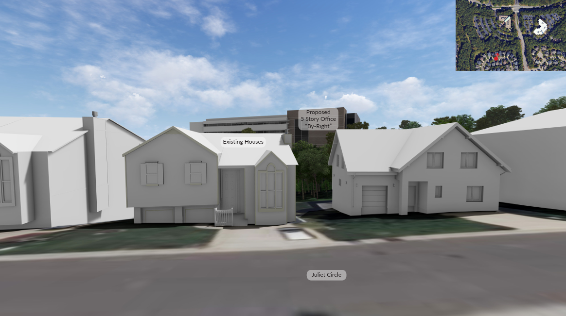
Street level view of by-right development from Juliet Circle
Aerial view of by-right development from Juliet Circle
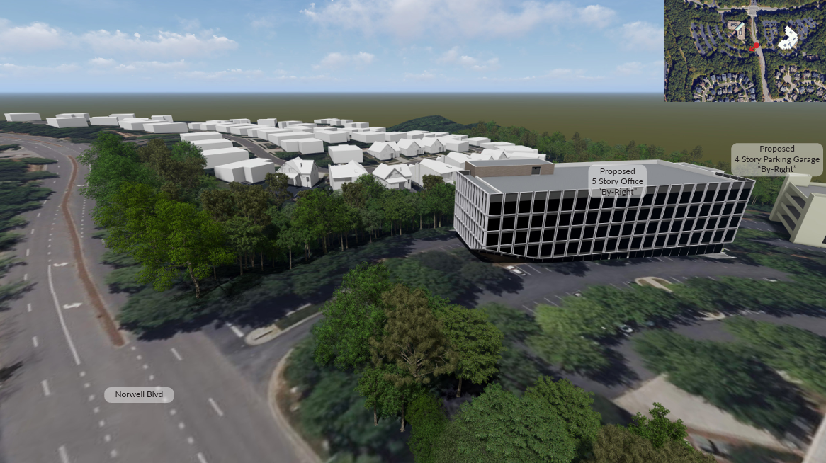
Aerial view of by-right development & neighborhood from Norwell Blvd
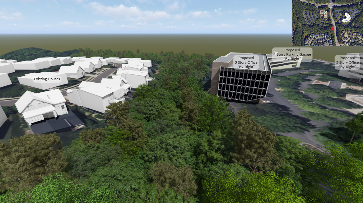
Aerial view of by-right development & neighborhood from Norwell Blvd
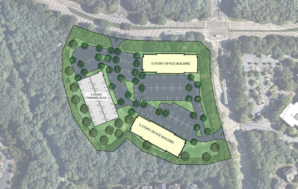
'By-Right' Site Plan
Council is not being asked to choose between development and no development. This site will be redeveloped. The question is what form that takes, and whether it reflects the direction Weston is heading.
The next chapter for this corner of Weston.
The rezoning before the Town Council transitions an office building at the end of its useful life into a mixed-use community that serves future residents, supports the surrounding office district with walkable retail and housing, and does so in a form that is more compatible with the adjacent neighborhood than what could be built on this site today, without any approval at all.
Frequently Asked Questions
-
You can view the full zoning conditions on the Town of Cary website. Linked here.
-
The existing office building is 57’ tall, and the new residential building can be a maximum of 75’ tall. Results from a balloon test conducted in January can be found here.
-
No, the proposed use will not generate more peak hour trips than the existing permitted office use. Primary access points are on Weston Parkway and Norwell Boulevard, the arterial roads that already serve the existing office building. Residential use generates a fundamentally different traffic pattern than office use — apartments produce fewer peak-hour trips than a fully occupied commercial office building, and the trips they do generate are spread more evenly across the day rather than concentrated in morning and evening commute windows. A traffic impact analysis has been completed as part of the rezoning process and can be found here.
-
Preserving the existing tree canopy along the southern and western edges of the site is a central feature of the proposed plan. The plan deliberately confines new construction to the corner of Weston Parkway and Norwell Boulevard, where the existing office building already sits, specifically so that the mature trees across the site can remain in place, as much as possible. Those trees, combined with the required landscape buffers and evergreen screen, form a layered system of separation between the new building and adjacent homes. By contrast, a by-right office redevelopment would likely require clearing much of that canopy to accommodate new buildings and structured parking across the full site.
-
The plan allows for between 1,500 and 5,000 square feet of ground-floor retail space along the Weston Parkway frontage. The specific tenant mix has not been determined at this stage of the process. The intent is neighborhood-serving retail that activates the street and serves both residents and the surrounding office community: think coffee, a small restaurant, or personal services.
-
The plan allows for up to 275 apartments, with a mix of studios, one-, two-, and three-bedroom homes. Resident parking is accommodated on-site within the existing surface parking area, which the plan preserves. Parking is calculated to meet Cary's requirements for the unit mix proposed. The plan does not rely on, and is not designed to encourage, overflow parking into the surrounding residential streets.
-
The site is designated as an Employment Mixed Use Center on the Imagine Cary Community Plan's Future Growth Framework Map — a designation that specifically supports a mix of commercial, office, and residential uses in a walkable pattern, with building heights of three to seven stories. The proposed rezoning is consistent with that designation in several ways.
On housing, the Community Plan calls for providing a variety of housing choices (Policy 2) and the greatest variety of housing options in mixed-use centers (Policy 4). Adding up to 275 apartments — including studios, one-, two-, and three-bedroom homes — contributes to that variety in a location already served by employment, transit, and infrastructure. The Plan also supports residential development on infill and redevelopment sites (Policy 5), which is precisely what this proposal represents: the conversion of a vacant, aging office building into a mixed-use residential community.
On affordable housing, the Plan calls for encouraging and supporting the provision of affordable dwellings (Policy 6). The applicant's commitment to maintaining at least 5% of units at 80% AMI for 30 years directly addresses this policy.
On land use and redevelopment, the Plan supports mixed-use development (Shape Policy 3) and redevelopment of underutilized sites (Shape Policy 4). This site — an aging, underutilized single-use office building along a major corridor originally developed in the 1980s and 1990s — is exactly the type of infill redevelopment opportunity the Plan envisions. The proposal also addresses transition policies (Shape Policy 6) through the variable-width Type A perimeter buffer, the densely planted evergreen screen, and the 75-foot building setback from the southern property line.
On transportation, the Plan emphasizes multimodal street design and accommodating pedestrians and cyclists (Move Policies 1–3). The proposed 12-foot-wide sidepaths along both Weston Parkway and Norwell Boulevard, combined with a greenway connection to the planned Weston greenway network to the west, directly respond to these policies.
On the environment, the 30- to 45-foot Type A perimeter buffer along the southern boundary contributes to tree canopy preservation (Enrich Policy 8), and the commitment to EV charging infrastructure addresses energy efficiency goals (Enrich Policy 6).
-
If the rezoning is approved, the site will be governed by the conditions of the rezoning, and the by-right office entitlement will no longer apply. The applicant would be bound to develop only what is permitted under the approved rezoning — including all conditions related to building height, setbacks, buffers, unit count, retail square footage, and the evergreen screen. The flexibility that exists under the current office zoning would be replaced by a more specific and constrained set of development standards that Council and the community have had the opportunity to review and shape.
-
Cary is one of the fastest-growing communities in the country, and housing supply has not kept pace with demand. The result is rising rents and home prices that make it increasingly difficult for workers, young professionals, and long-time residents to afford to live in the community where they work. Adding housing in established, well-served locations — close to employment, transit, and services — is more efficient and less impactful than pushing new housing further out into undeveloped areas. This site, already served by existing infrastructure and adjacent to a major employment corridor, is exactly the kind of location where new housing makes sense.
-
Following approval of the rezoning, the applicant would proceed with building design and permitting. Construction is anticipated to begin in 2027 and would take approximately 18 months to complete. The applicant is committed to being a good neighbor during construction, including adhering to Town of Cary noise ordinance hours and coordinating truck routes to minimize impacts on the surrounding residential streets.
-
Yes, as a condition of rezoning approval, 5% of units will be maintained as affordable for households earning at or below 80% of the area median income for a minimum period of 30 years. This commitment ensures that a portion of the housing at this location remains accessible to working households for decades to come, not just at initial lease-up.